


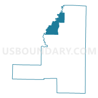
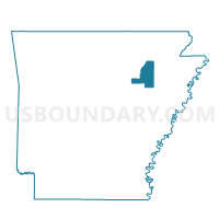
Waters Store Voting District, Jackson County, Arkansas
About
Outline

Summary
| Unique Area Identifier | 526768 |
| Name | Waters Store Voting District |
| County | Jackson County |
| State | Arkansas |
| Area (square miles) | 32.67 |
| Land Area (square miles) | 32.04 |
| Water Area (square miles) | 0.64 |
| % of Land Area | 98.05 |
| % of Water Area | 1.95 |
| Latitude of the Internal Point | 35.75979400 |
| Longtitude of the Internal Point | -91.25553370 |
Maps

Graphs
Select a template below for downloading or customizing gragh for Waters Store Voting District, Jackson County, Arkansas


Neighbors
Neighoring Voting District (by Name) Neighboring Voting District on the Map
- Big Bottom-Wycough-Logan Voting District, Independence County, AR
- Blackriver Marshall Voting District, Independence County, AR
- Hickory Grove Voting District, Jackson County, AR
- Swifton Voting District, Jackson County, AR
- Tuckerman Outside Voting District, Jackson County, AR
Top 10 Neighboring County Subdivision (by Population) Neighboring County Subdivision on the Map
- Bird township, Jackson County, AR (2,102)
- Big Bottom-Wycough-Logan township, Independence County, AR (1,927)
- Glass township, Jackson County, AR (1,088)
- Jefferson township, Jackson County, AR (1,064)
- Black River-Marshell township, Independence County, AR (341)
Top 10 Neighboring Unified School District (by Population) Neighboring Unified School District on the Map
- Newport School District, AR (11,706)
- Cedar Ridge School District, AR (5,465)
- Jackson County School District, AR (4,609)